March 8, 2023 •Déborah
LiDAR is increasingly used in various sectors. It never ceases to amaze us with its efficiency and precision defying all technologies. You already know it, this technology is based on data carried out using lasers which create a cloud of 3D points representing the scanned area. From this cloud, we can then draw a lot of information: measurements, template studies, inventories, etc. Obtaining this essential information for business applications requires different methods: classification (of the objects making up the point cloud) but also vectorization! Indeed, vectorization is an essential step for the analysis of the cloud and the development of calculations from it. But then, let’s have a closer look at what point cloud vectorization is…
Point cloud vectorization, what is it?
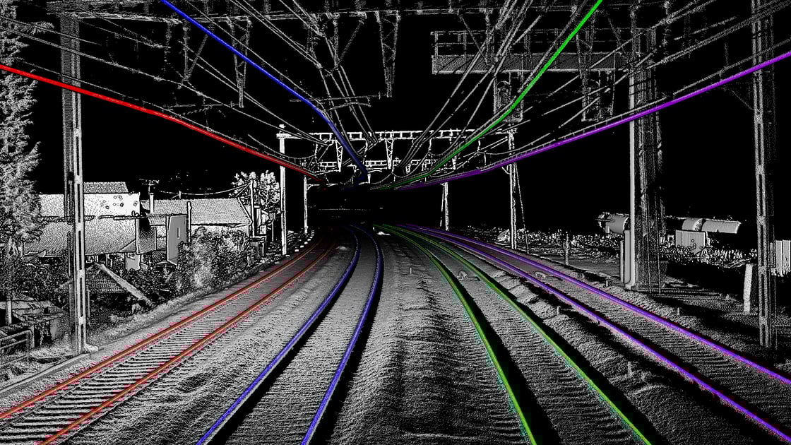
First, we can focus on what the 3D point cloud vectorization process represents. In a nutshell, vectorization makes it possible to draw “lines” from the points of the cloud. For example, in the railway environment, we may wish to vectorize rails and cables. For this, we use the data of the collected points which then make it possible to constitute lines on the cloud: the polylines. This is called vectorization. There is no denying that this processing of the point cloud is particularly useful in the railway, highway and industrial fields insofar as vectorization makes it possible to create or complete the GIS or BIM model of the concerned site. Moreover, this vectorization can be used in many other ways…
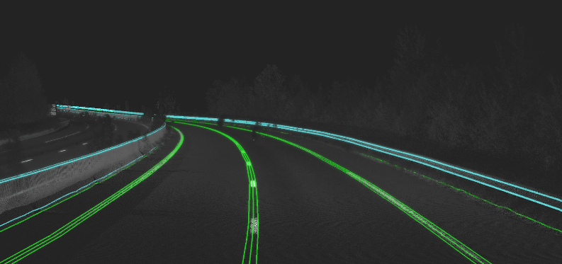
Highway Automated Vectorization - TheCrossProduct
But, what is the use of these polylines?
Once we have obtained the polylines thanks to vectorization, we may wonder what will we use it for? This already makes it possible to complete the GIS and BIM models of the infrastructures, in order to improve knowledge and the sharing of information on the infrastructure, but the usefulness is generally more direct. In the sector of professional applications, vectorization makes it possible to automate measurements: width of tracks, width of markings on the ground, height of guardrails, cant of tracks, cant of rails, gauge of rails, etc. These measurements can then be restored in the form of a graphic synoptic allowing easy visualization of the geometry of the tracks. Vectorization also makes it possible to carry out more complex studies. In the highway and railway sectors, polylines are used to carry out reverse engineering studies of the geometry of the road (calculation of horizontal and vertical alignments). This reverse engineering consists of detecting straight lines, bends with their radius of curvature, slopes, etc. This then makes it possible to check compliance, plan extension works, etc. Another example of application is clash detection: thanks to polylines, it is possible to circulate a virtual gage and detect possible collisions. Finally, a last example is the detection of rail deformation, allowing to optimize maintenance processes by identifying, in the blink of an eye, all deformation issues requiring intervention.
And how to do this polyline vectorization?
We can now wonder how to carry out point cloud vectorization in an accurate and efficient way. Indeed, at the point cloud classification stage, it is possible to vectorize the cloud manually: with the right tools, designers can draw the polylines in the point cloud. On the other hand, this method can, like classification, prove to be long and tedious. Especially since the precision of manual vectorization can sometimes be inaccurate. In addition, manual vectorization requires special knowledge and training in this process, which can then make this step even more laborious. Another method is then adapted: automatic vectorization! Indeed, it is possible, thanks to point cloud vectorization automation software, to obtain results quickly, reliably and precisely, and above all, specific to each business need! This method allows the user to simply send their data to the cloud and get their point cloud vectorized. This is a hybrid solution combining Artificial Intelligence, deterministic algorithms and specific business knowledge to provide an accessible solution. Software like the one of the deeptech TheCrossProduct makes vectorization obvious, automatically. We can for example mention the product Railway Automated Vectorization or Automated Road Modelling. Thanks to its industrial and academic experience in the field of 3D point cloud processing research, TheCrossProduct offers state-of-the-art software!

Railway Automated Vectorization - TheCrossProduct
Finally, the vectorization of point clouds is a very important step in the processing of LiDAR data since it thus makes it possible to concretely exploit point clouds and take advantage of the benefits of LiDAR digitization. This process can then be carried out using automatic tools, relevant and adapted to a business need, such as Railway Automated Vectorization from TheCrossProduct. As always, fast and reliable processing for the benefit of innovation, development and safety!
Still more questions about point clouds and LiDAR? How to visualize point clouds ? How to classify point clouds? Find some answers here: https://www.thecrossproduct.com/en/faq!